What Projection Mapping Really Is
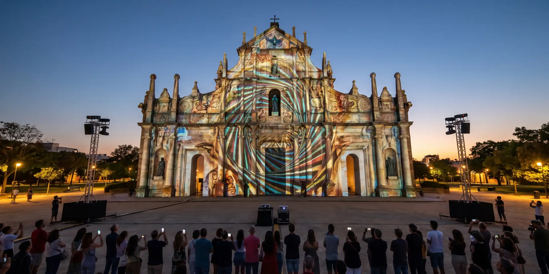
Projection mapping is a display method that aligns video to the exact shape of a physical object. A normal projector throws a flat rectangle onto a screen. This method does the opposite. It shapes the image to fit a wall, dome, statue, or stage, so the surface itself holds the picture. The technique is also called video mapping or spatial augmented reality.
A projection mapping setup has three parts:
- Projectors that throw a bright image onto the surface.
- Mapping software that bends and masks the visuals to fit the object.
- Content, the animation or short film that plays across it.
The software studies the surface and warps each frame so the visuals land in the right place. On a curved arch or a carved facade, the image follows every edge and recess. A cathedral front, a fort wall, or a tall statue can all serve as the surface. Done well, the result makes solid stone look like it moves, opens, or changes material.
The Trick Behind 3D Projection Mapping
3d projection mapping goes one step past flat projection. It uses an accurate three dimensional model of the object, so the visuals track the real geometry of the surface. Depth, angles, and corners all line up with the light.
That accuracy creates the illusion. A plain facade can appear to crack open, grow patterns, or fold into new shapes, because the light respects where each edge sits in space. Flat projection cannot manage this on complex surfaces. This is why large monuments and detailed buildings almost always use 3d projection mapping instead of a simple wash of video. The rule is direct. The more carving and detail a surface has, the more a 3d projection mapping model has to work with, and the stronger the final result.
Why Protected Sites Choose Monument Projection
Monument projection has one feature that matters most to heritage teams. It touches nothing. There are no drills, no anchors, and no scaffolding fixed to the stone. Projectors sit on towers or stands placed at a distance, and the light does the rest. Power and control cables run to the projector positions, not to the monument, so there is no trenching or fixing on the protected site.
This makes the method a strong fit for protected sites, where conservation rules limit any physical change. International conservation guidance, including the principles published by ICOMOS, stresses minimal intervention and reversibility for heritage structures. A monument projection show meets both tests. When the projectors switch off, the site is exactly as it was before.
The practical advantages include:
- No contact with the original surface.
- Full reversibility, because the equipment is removed after the show.
- No added weight or fixtures on fragile stone.
- A method that works on marble, sandstone, brick, and mixed facades.
In our experience, this removes the usual conflict between drawing crowds and protecting the structure. A monument projection show lets a site do both on the same night.
Inside a Building Projection Mapping Project
Building projection mapping follows a clear order. Each stage feeds the next, and a weak stage shows up on the wall. Here is how we run a full building projection mapping project.
Capture and Model
- We scan the structure with LiDAR, photogrammetry, or drone mapping to record its exact shape.
- The scan becomes a precise 3D model, or digital twin, of the building.
- That same scan can also feed an off-site immersive experience centre that runs alongside the live show.
Design and Produce
- We build a story from the site’s own history and meaning.
- Our animators create the content against the 3D model, so every frame matches the surface.
- We time the film to a music track and, in most cases, a narration.
Install and Calibrate
- We select projectors for brightness, measured in lumens, and for throw distance, then place them and, outdoors, weatherproof them.
- We blend several projectors at the edges, so the image reads as one picture across a wide facade.
- On site, we calibrate and warp the visuals to match the real geometry before the first public show.
Good building projection mapping depends on that first scan. If the model is even slightly off, the light drifts past the edges and the effect breaks. This is the stage where accuracy is won or lost.
Permanent Show or One Night Only?
Projection mapping runs in two formats, and the choice shapes both the budget and the hardware.
- Permanent installations use fixed, weatherproof projectors for a nightly show. These suit monuments and tourism sites that want a repeatable evening attraction with ticket sales.
- Temporary shows are built for a single event, such as a festival, a product launch, or a summit. The equipment is rented, installed, run, and then removed.
Older sound and light shows lit a monument with static floodlights and a voice track. The newer method replaces the fixed light with animation mapped to the surface, so the building appears to change. The same skills also drive indoor work, from museum galleries to projection-mapped brand environments at large events. Big public monuments show the permanent model clearly. At sites such as the Statue of Unity, evening light and video shows draw steady crowds and give the venue a reason to sell tickets after dark.
What Tourism Boards Gain
For a tourism board, projection mapping is a way to earn more from a site that already exists. The building is already there. The show adds hours, footfall, and reasons to come back. Word of mouth and social media stretch that further, because a striking night show gets filmed and shared, which pulls in first time visitors.
The technique supports tourism goals in direct ways:
- It extends visiting hours into the evening, which grows the local night economy.
- It raises footfall and dwell time, so visitors stay longer and spend more nearby.
- It creates a ticketed attraction with revenue a department can measure.
- It can carry the story in several languages, which widens the audience.
Heritage bodies now treat visitor experience as part of how they fund upkeep, and guidance from organisations such as UNESCO links sustainable tourism to the long term care of world heritage sites. A well run show gives a site a way to pay for maintenance while keeping the structure untouched. This is a core reason monument projection has spread across so many public sites.
Planning a Monument Projection Show That Works
A monument projection project only works when the 3D capture, the content, and the projector engineering hold together. That is where experience matters. We have spent more than ten years building immersive work, with over one hundred projects delivered and a 96 percent success rate across government, museum, and corporate clients.
That record includes high pressure public events. For the Varanasi ropeway VR experience, we used drone aerial mapping and precise 3D modelling to build a live demonstration for a national inauguration, run in front of senior government officials with zero glitches. The same capture and modelling skills sit behind any building projection mapping project.
Cultural work runs through the portfolio too. We built interactive galleries for the CSMVS museum, turning heritage content into experiences visitors can explore by hand. The same core skills carry a show from first scan to final night.
To scope a monument projection show for a heritage or tourism site, speak with the ViitorX team.
What It Comes Down To
Projection mapping gives heritage and tourism teams a way to light a monument with moving visuals at night without changing a single stone. 3d projection mapping creates depth on complex surfaces, building projection mapping delivers it through accurate capture and calibration, and monument projection keeps the whole process reversible. For any site that goes dark and quiet after sunset, a well planned show turns the evening into an attraction that funds itself.
Frequently Asked Questions
What is projection mapping?
Projection mapping is a display technique that aligns video to the exact shape of a physical surface, such as a building, a statue, or a stage. Instead of a flat screen, the object itself carries the image. It is also called video mapping or spatial augmented reality.
How does projection mapping work?
A projector sends light onto the surface while mapping software warps each frame to fit it. The software matches the visuals to the real edges and curves of the object, so the animation stays aligned as it plays. Every setup comes down to three parts: the projectors, the software, and the content.
What is the difference between projection mapping and 3d projection mapping?
Flat projection treats the surface as a plane. The 3D version uses an accurate three dimensional model of the object, so the visuals follow its depth, angles, and corners. This is why it suits carved facades and detailed monuments, where the effect depends on the light tracking the real geometry.
Does projection mapping damage a monument?
No. Monument projection is a non-contact method, so the projectors sit on stands or towers at a distance. Nothing is drilled, mounted, or fixed to the stone. When the show ends, the equipment is removed and the site is left exactly as it was.
How is building projection mapping produced?
The process starts with a 3D scan of the structure, captured using LiDAR, photogrammetry, or a drone. That scan becomes a digital model, and the content is designed against it so every frame fits. We place, blend, and calibrate the projectors on site before the first public show.
How much does a projection mapping show cost?
The budget depends on the size of the surface, the number and brightness of the projectors, the length of the show, and whether it is permanent or temporary. A larger facade needs more and brighter units, which is the main cost driver. A permanent installation also adds weatherproof housings and the cost of running the show each night.
Is a permanent show or a one-time event better?
Both formats work, and the goal decides the choice. A permanent installation uses fixed, weatherproof projectors for a nightly ticketed show, which suits monuments and popular tourism sites. A temporary setup is rented, installed, and removed for a single festival, launch, or public event.